Mount Kearsarge and Baker's Ledge
| Destinations: | Mt. Kearsarge (2930'), Baker's Ledge (1650') | |
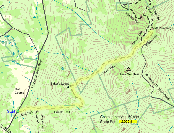
| Trails: | Link Trail, Lincoln Trail, Rollins Trail, Sunapee-Ragged-Kearsarge Greenway | |
| Region: | NH - Central West Mount Kearsarge State Forest | |
| Location: | Sutton, NH | |
| Rating: | Easy/Moderate | |
| Features: | Summit, views, fire tower | |
| Distance: | 9.2 miles | |
| Elevation Gain: | 2100 feet (cumulative) | |
| Hiking Time: | Actual: 6:00 Typical: 5:35 | |
| Outing Duration: | Typical: 8:00 | |
| Season: | Spring | |
| Hike Date: | 06/03/2000 | |
| Last Updated: | 05/03/2009 | |
| Weather: | Clear, sunny | |
| Author: | Webmaster | |
| Companions: | SDHrs: Dennis M, Rich, John, Carol & Dick F, Chris & Monsie D, Trish, Diane B, Barbara, Linda H, Sara B, Sal S, Dave S, Jane L, + 1 or 2 more (brain overload) |
Route Summary
This is hike up to Mount Kearsarge with outstanding 360-degree views from its bare summit.
Ascent
- Start on Link Trail and follow it for 0.5 mile.
- At the junction with Lincoln Trail, turn left to follow it uphill. The Lincoln Trail is part of the Sunapee-Ragged-Kearsarge Greenway.
- Stay straight on this wide trail for 1.0 mile.
- Then turn left onto a medium-width trail (still the Lincoln Trail) and follow it for 0.5 mile.
- At this point there were will be a spur path marked "scenic route". Turn left here and follow the faint footway for about 0.1 mile until reaching Baker's Ledge with a nice outlook.
- Retrace your steps back to Lincoln Trail and turn left to resume the trek.
- Continue following Lincoln Trail, now a narrow footpath, for another 2.0 miles.
- At this point you will arrive at Rollins State Park and have a choice of ascending the remaining segment via Lincoln Trail (rougher) or Rollins Trail (easier).
- We followed Rollins Trail for the final 0.5 mile to Mount Kearsarge's summit.
Descent
- For the descent, we followed Rollins Trail for 0.5 where it ends at a parking area.
- Then we retraced our steps on Lincoln Trail.
- After 3.0 miles on Lincoln Trail, turn right at the junction with the wide path (still Lincoln Trail).
- Descend this snowmobile trail for another mile, then turn right onto Link Trail.
- Follow Link Trail for 0.5 mile back to the parking area on Kearsarge Valley Road.
| Place | Split Miles |
Total Miles |
||
|---|---|---|---|---|
| Link Trailhead on Kearsarge Valley Road (850') | 0.0 | 0.0 | ||
| Jct. Link Trail/Lincoln Trail (1050') | 0.5 | 0.5 | ||
| Jct. Lincoln Trail/Baker's Ledge spur trail (1650') | 1.5 | 2.0 | ||
| Baker's Ledge (1650') | 0.1 | 2.1 | ||
| Jct. Lincoln Trail/Baker's Ledge spur trail (1650') | 0.1 | 2.2 | ||
| Rollins State Park parking area (2600') | 2.0 | 4.2 | ||
| Mt. Kearsarge summit (2930') | 0.5 | 4.7 | ||
| Rollins State Park parking area (2600') | 0.5 | 5.2 | ||
| Jct. Lincoln Trail/Baker's Ledge spur trail (1650') | 2.0 | 7.2 | ||
| Jct. Link Trail/Lincoln Trail (1050') | 1.5 | 8.7 | ||
| Link Trailhead on Kearsarge Valley Road (850') | 0.5 | 9.2 |
|
|
|||||
|
|
|||||
|
|
|||||

Trail Guide
 Eighteen enthusiastic souls showed up for the Mount Kearsarge trek. For the first half-mile,
the path meandered around neat looking boulders, through deeply shaded woods. The next
mile and a half was a wide route that doubles as a snowmobile trail. Bright green tiger
beetles were sunning themselves on the rocks and flying about only when threatened by
a nearby hiking boot. We saw a snake and some toads and there were a few clumps of
fringed polygala (small, low growing purplish wildflowers resembling orchids) growing
along the trail edge. Shortly before reaching Baker's Ledge, there was a huge ant
hill about a foot high. The bushes surrounding the mound were dead - likely due to
the ants disturbing their root system.
Eighteen enthusiastic souls showed up for the Mount Kearsarge trek. For the first half-mile,
the path meandered around neat looking boulders, through deeply shaded woods. The next
mile and a half was a wide route that doubles as a snowmobile trail. Bright green tiger
beetles were sunning themselves on the rocks and flying about only when threatened by
a nearby hiking boot. We saw a snake and some toads and there were a few clumps of
fringed polygala (small, low growing purplish wildflowers resembling orchids) growing
along the trail edge. Shortly before reaching Baker's Ledge, there was a huge ant
hill about a foot high. The bushes surrounding the mound were dead - likely due to
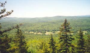
the ants disturbing their root system.Baker's Ledge marked the two-mile point. A small group took the spur path to check out the views from the cliff. Close at hand we could see the golf course that's on the same road as the trailhead. But far more impressive were the outlooks towards Sunapee - lots of lush green trees and mountains interspersed with a sprinkling of lakes for as far as the eye could see.
Note: The trail to Baker's Ledge seemed to be slightly re-routed from last time I was there. A sign stating "scenic route" points to the spur path that starts out faintly. It then crosses over a stone wall staying to the left of a big pool of water and a large downed tree (I think last time, the water wasn't there and I climbed over that tree). Shortly after going through the stone wall, it rejoins the path that I followed last year.
 While hiking the next two miles above the ledge, it felt like we were in the jungle.
The path was narrow with lots of wild overgrowth; a few downed trees we had to climb
over and abundant mosquitoes and black flies which plagued us most of the day. There
were plenty of blue bead lilies, a smattering of painted trilliums, lady's slippers,
and rose twisted-stalk. We even saw one red trillium, which is also known as "wet dog" because it reputedly has an
unpleasant odor (although I've never been able to detect one). Rose twisted-stalk seems unassuming at first glance because it looks
like a simple green-leafed plant - but dangling downward from the stalk, almost hidden
by each of the leaves, are delicate bell-shaped, pink flowers.
While hiking the next two miles above the ledge, it felt like we were in the jungle.
The path was narrow with lots of wild overgrowth; a few downed trees we had to climb
over and abundant mosquitoes and black flies which plagued us most of the day. There
were plenty of blue bead lilies, a smattering of painted trilliums, lady's slippers,
and rose twisted-stalk. We even saw one red trillium, which is also known as "wet dog" because it reputedly has an
unpleasant odor (although I've never been able to detect one). Rose twisted-stalk seems unassuming at first glance because it looks
like a simple green-leafed plant - but dangling downward from the stalk, almost hidden
by each of the leaves, are delicate bell-shaped, pink flowers.After a short, challenging pitch, we came upon an open rocky area where we were rewarded with some pleasant views while resting up for the remainder of the climb. Continuing our "jungle" walk, we eventually entered a grove of old, twisted birch trees, and soon after that we reached the parking lot for Rollins State Park which meant we only had a half-mile to go. By this time lots of people were wishing our cars were waiting here for us.
The final half-mile was easy grades up a well-traveled path. There were rhodora growing along the sidelines, which is similar to a rhododendron but is a smaller shrub with narrow leaves and daintier flowers. We also saw a yellow-rumped warbler ("butterbutt") along this section. (Thanks to Jane for all these great identifications throughout the day!) One group took a detour off the wide gravel/rocky route and found a neat woods path that also led to the summit, but approached it from the opposite direction (this may have been the continuation of Lincoln Trail).

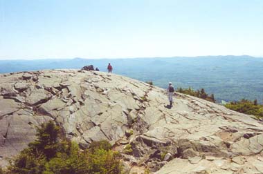
The summit is a large, open, rocky area and the clear skies afforded fantastic views in all directions. The wind was refreshing and more importantly, it kept the bugs away so we could eat our well-deserved lunches in peace. Although our group comprised the only people on the trail below the parking lot, the top was quite populated due to the close proximity of the two state parks (from Winslow's parking area, it is a one mile hike up to the summit). One person was making a kite perform acrobatic feats by controlling it with two strings and the kite produced loud whooshing noises as it cut through the wind. Several kids were having fun running up and down the stairs to the fire tower.

After basking in the sun for a while and posing for the requisite photos, we headed back down the path. There are several other routes that intersect with the Lincoln Trail (which we followed for most of our hike) and I wondered where they went to. Thanks to some missed turns, I got to find out. Part of the group missed the turn off the wide snowmobile trail (0.5 mile from the bottom) and ended up coming out a couple miles away from the trailhead; going straight on Lincoln Trail instead of turning right onto Link Trail ends up leading to Kearsarge Regional High School. Luckily they were able to hitch a ride with someone back to the cars. And a couple other factions missed a different turn and ended up coming out by the golf course - about a half-mile down the road from the trailhead. We all made it back safe and sound, although we were weary and speckled with bug bites.
It took about 3.5 hours for the whole group to make it to the summit; and about 2.5 hours for the whole group to descend.

|
|
|||||

|
|||||

The trailhead for this hike is located in Sutton, New Hampshire.
- From I-89 take exit 10 (sign says "To 114" and there's also a brown sign that says "Winslow State Park").
- At the bottom of the exit ramp, head east.
- Very shortly you come to a T-stop.
- Go right onto North Road and follow that for 0.4 mile.
- Turn left onto Kearsarge Valley Road and follow that also for 0.4 mile
- Turn right into a fairly obvious cleared dirt/grass parking area. (If you reach the golf course, you've gone 0.4 mile too far.)
- There are no signs at the actual parking area - but a trailhead sign is visible just inside the woods from the parking area. It's at about the center of the parking area.
About Sunapee-Ragged-Kearsarge Greenway
The Sunapee-Ragged-Kearsarge Greenway (SRKG) is a 75-mile "emerald necklace" (in the words of the SRKG Coalition) hiking trail located about 25 miles northwest of Concord, New Hampshire. This route forms a big
The name of the greenway comes from the fact that the trail hikes over the summits of Mount Sunapee (2726'), Ragged Mountain (2225'), and Mount Kearsarge (2930'). Lake Sunapee is completely within this "necklace" and one section of the SRKG passes by its southern tip. The "Greenway" part of the name comes from the fact that the trail passes through forests and areas that for the most part have seen little development.
The Greenway was first conceived in 1990 and relies heavily on the goodwill of the private landowners whose property it passes over. Please respect their generosity by parking responsibly, staying on the trail, not littering, and picking up any stray trash you happen to see during your walk. The SRKG passes through ten New Hampshire towns: Andover, Danbury, Goshen, Newbury, New London, Springfield, Sunapee, Sutton, Warner, and Wilmot.
Sunapee-Ragged-Kearsarge Greenway Property Use Guidelines
- Dogs are not allowed.
- Camping is not allowed.
More Mt. Kearsarge and Greenway Trail Reports
Website by
![]() LeapfrogProgramming.com
LeapfrogProgramming.com
© 1998-2026
![]()
| The information on this site may freely be used for personal purposes but may not be replicated on other websites or publications. If you want to reference some content on this site, please link to us. |


