| Mountain: | Beech Mtn. (839') | |
| Trails: | Valley Trail, Beech South Ridge Trail, Beech Mountain Trail | |
| Region: | ME - Central Southeast Acadia National Park, Western Region | |
| Location: | Southwest Harbor, ME | |
| Rating: | Easy/Moderate | |
| Features: | Summit, views, cliffs, slab caves, fire tower, loop hike | |
| Distance: | 2.4 miles | |
| Elevation Gain: | 450 feet (cumulative) | |
| Hiking Time: | Actual: 1:25 Typical: 1:25 | |
| Outing Duration: | Actual: 2:45 Typical: 2:45 | |
| Season: | Spring | |
| Hike Date: | 06/09/2008 (Monday) | |
| Last Updated: | 10/22/2009 | |
| Weather: | 80 degrees | |
| Author: | Webmaster |

Route Summary
This loop hike summits Beech Mountain in Acadia National Park. There is a fire tower at the top and great views in almost every direction from the summit and along the trail.
First, in order to clear up any confusion, a few notes on names:
- Beech Mountain Trail may also be referred to as Beech Mountain Loop Trail, or simply Beach Mountain Loop. The park service has renamed several trails so you may come across either name on signs and other references.
- Beech South Ridge Trail may also be referred to as Beech Mountain South Ridge Trail. This is another route that underwent a name change as part of the park's management plan. Many of the changes revert to an earlier historical name.
- Beech West Ridge Trail may also be referred to as Beech Mountain West Ridge Trail.
To Beech Mountain:
- From the Beech Mountain parking lot, pick up Valley Trail which leaves from the far left-hand corner of the lot (the end opposite from where you drove in).
- Follow Valley Trail for 0.2 mile which will bring you to a junction with Canada Cliff Trail. Keep straight on Valley Trail.
- After another 0.6 mile on Valley Trail you will reach a junction with Beech South Ridge Trail. Turn right, up the stone steps onto Beech South Ridge Trail while Valley Trail continues straight.
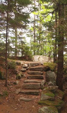
- Climb up Beech South Ridge Trail, much of the way on rock steps, for 0.8 mile to arrive at the summit of Beech Mountain where the fire tower is.

Return:
- After enjoying the summit, continue a few strides past the fire tower where you will see a trail junction. Beech Mountain Trail goes both straight (north) and left (west). Turn left to take the more scenic route down.
- After 0.1 mile you will reach a junction with Beech West Ridge Trail which goes to the left; stay straight/right to keep following Beech Mountain Trail.
- Descend for 0.6 mile, with views along the upper portion.
- Then, the other leg of Beech Mountain Trail will come in from the right. Keep straight and reach the parking lot in less than 0.1 mile.
| Place | Split Miles |
Total Miles |
Split Time |
Total Time |
|||||
|---|---|---|---|---|---|---|---|---|---|
| Beech Mtn. parking lot (500') | 0.0 | 0.0 | 0:00 | 0:00 | |||||
| Jct. Valley Trail/Beech South Ridge Trail (400') | 0.8 | 0.8 | 0:30 | 0:30 | |||||
| Beech Mtn. summit (839') | 0.8 | 1.6 | 0:30 | 1:00 | |||||
| Beech Mtn. parking lot (500') | 0.8 | 2.4 | 0:25 | 1:25 |

|
|
|||||

|
|
|||||


Trail Guide
This loop hike starts out in shady woods running along the base of Beech Mountain's steep cliffs, then it swings around to summit the mountain by walking atop those same cliffs along the ridgeline. There are many great views along the way and a fire tower at the top.
I started out on Valley Trail which was flat, and even slightly downhill all the way. The trees lining the path presented a kaleidoscope of greens and the smooth footway was an unexpected change from much of the more rugged hiking at Acadia. As soon as I entered the woods, the deep shade was a dramatic change and in addition to noticing the beauty, I also became aware of the buzzing of mosquitoes. I grabbed a Bounce fabric sheet from my pack, rubbed it over my clothes then popped it loosely into my shirt pocket. Strange as this sounds, this trick has actually proven effective every time I've tried it – but for mosquitoes only; as for black flies, it seems to attract them.
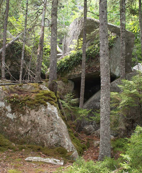
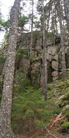
With the little beasts kept at bay, I could better enjoy the hike. After about 0.3 mile, boulders started to appear trailside although the path itself was still smooth with the small elevation changes assisted by easy rock steps. The boulder jumbles became more numerous with the Beech Mountain cliffs rising up sharply behind them on the right.

Moss, lichen, and ferns made the rocks even more interesting. Appalachian polypody (Polypodium appalachianum) – more commonly know as rock cap fern – is a small evergreen fern topping many of the boulders. One large pile of boulders forms some slab caves and with all the decorative moss and ferns adorning the faces, it looked like quite an inviting and unique home in the woods.
Continuing along, some of the footway changed to smooth ledge and bunchberry plants (Cornus canadensis), also known as Canada dogwood, were in bloom low to the ground. One boulder I passed by was in the shape of a triangle and was about twelve feet high.
I soon reached the junction with Beech South Ridge Trail which marked the start of the ascent to the summit. I turned right and began winding upwards on wonderful rock staircases... several steps and then smooth trail... then a few more steps. I got some close-up looks at rock tripe covering the boulders in brown, flaky patches and some neat little orange-colored mushrooms.

The trail continued to alternate rock steps with flat stretches with more and more views of the cliffs on Beech Mountain's eastern flanks. Soon enough, I reached the first ledgy outlook where there were water views in one direction and the fire tower visible up in the other direction. I continued to climb easily winding across ledges with varying amounts of views. There was an outlook just off the trail to the right with 180-degree vistas.
From the summit you can get views to almost every direction by walking around a bit. The fire tower's cabin is locked but you can go up the stairs to just below the cabin which will gain you about a dozen feet in elevation – although the northwest quadrant will still be partially obstructed. Views of mountains, both near and far were visible, as were ponds, the ocean, islands, and forest.
I had planned on having a leisurely lunch on the summit but when I stopped moving the black flies viciously attacked me and left me bloodied and scrambling to get away. Past the fire tower, I turned left, and then right to follow the west branch of Beech Mountain Trail for the descent.

This is a great trail skirting the outer edge of the mountain and I was soon treated to clear views to the northwest that had been blocked from the summit. Long Pond, which is nearly two miles in length, stretched out from the base of Beech Mountain's western cliffs to the north. The views beyond to mountains and waterways were also beautiful.
The trail descended easily, popping in and out of woods before finally dipping permanently into the forest and soon arriving back at the parking lot. This was a satisfying late-afternoon hike and since I had started late, I even got to see some of the vistas bathed in the golden glow of the setting sun.

|
|
|||||


|
|
|||||


|
This hike starts from the Beech Mountain parking lot at the end of Beech Hill Road, located within Acadia National Park in Southwest Harbor, Maine. It is in the western half of Mount Desert Island.
 From the North:
- From the junction of Routes 3 and 102 in Bar Harbor, pick up Rt. 102 South.
- Follow Rt. 102 South for about 5.3 miles.
- Where Rt. 102 splits, turn right onto its western branch which is also called Pretty Marsh Road.
- Drive for 0.25 mile then turn left onto Beech Hill Road.
- Follow Beech Hill Road for 3.1 miles until it ends at the Beech Mountain parking lot.
From the East:
- From the junction of Routes 3 and 233 in Bar Harbor, pick up Rt. 233 West.
- Follow Rt. 233 West for about 5.9 miles where it will end upon meeting Routes 3 and 198.
- Turn right and follow Rt. 198 North for about 1.4 miles where it will reach a junction with Rt. 102.
- Turn left and follow Rt. 102 South for about 0.9 mile.
- Where Rt. 102 splits, turn right onto its western branch which is also called Pretty Marsh Road.
- Drive for 0.25 mile then turn left onto Beech Hill Road.
- Follow Beech Hill Road for 3.1 miles until it ends at the Beech Mountain parking lot.
Winter: The parking lot is not plowed in winter but you should be able to park at the end of the road.
Other Notes
A fee is required to enter Acadia National Park between May 1st and October 31st.
For more information on entrance fees please refer to the Acadia National Park website.
Rates:
- $20 for a week-long pass for one vehicle during the regular season (June 23rd–Early October)
- $10 for a week-long pass for one vehicle during the off-season (May 1st–June 22nd and Early October–October 31st)
- $40 for a year-long pass for one vehicle
- $5 for a week-long pass for one pedestrian

About Acadia National Park
Acadia National Park, covering about 48,000 acres, is located on Mount Desert Island on the coast of the Atlantic Ocean in the "Downeast" region of the state of Maine. The park spans several villages including Bar Harbor, Northeast Harbor, and Southwest Harbor. Acadia includes miles of ocean shoreline, many freshwater ponds, a couple lakes, waterfalls, bare ledgy mountaintops, and deciduous and softwood forests. There are two sections of the park that are not on Mount Desert Island: Schoodic Peninsula and Isle au Haut.
Acadia National Park offers a unique hiking experience in New England. From the many bare summits, not only can you see other mountains, but also gorgeous vistas of the sea along with islands, promontories, coves, and boats. The hiking is rugged with many easy rock scrambles, yet the elevations are low, making the ledgy peaks accessible to most people. The incredible network of trails allows you to tailor hiking distances to your wishes – you can devise a route that will keep you going all day; or simply choose a short jaunt to give you great vistas without a lot of effort. There are a couple dozen peaks and well over 100 miles of hiking trails.

There is an abundance of opportunities for outdoor activities at Acadia. Spend some time sunbathing at Sand Beach, enjoy a leisurely stroll along the Atlantic shoreline, bicycle or ride a horse on the 57 miles of carriage roads, paddle in the many ponds, swim at Echo Lake, take a boat tour on the sea or to an island, stay overnight at the park's campgrounds, and of course you can hike up mountains, through forests, and around ponds. The winter season provides great terrain for cross-country skiing and snowshoeing.
If your taste runs to less physical activity, then you can drive up to the summit of Cadillac Mountain – Acadia's highest peak at 1,532 feet elevation – in fact the highest point on the United States' Atlantic seaboard. From Cadillac's bare summit are views in every direction – you can watch the sunrise in the morning and the sunset in the evening. The forest service offers many ranger-led programs from mid-May through mid-October to introduce you to the nature and wildlife of the park. You can drive on Park Loop Road for a tour of the park with many picnic areas and pullout spots offering scenic vistas available. Or stop in at Jordan Pond House for popovers and tea. Shopping, restaurants, and lodging are available in Bar Harbor as well as the other villages within or next to the park. Whale watching and bird watching are other popular activates.

The varied natural habitat of Acadia National Park – from ocean to mountains – offers a plethora of plants and wildlife – both marine and land-bound. It is home to about 50 species of mammals, 325 bird species, and 1,000 species of flowering plants. Both bald eagles and peregrine falcons nest on the island. Mammals include deer, porcupine, and beaver. Whales and harbor seals are common marine animals.
The park was established in 1916 under a different name and became Acadia National Park in 1929. John D. Rockefeller, Jr. donated about one-third of the park's acreage and was responsible for creating the gorgeous carriage roads that wind through forests, around ponds, past waterfalls, and over beautiful granite bridges.
An entrance fee is required to enter the park. See the forest service's Fees and Reservations page for more information.
The park is open all year, although services are reduced and many roads closed during the winter season.
Acadia National Park
P.O. Box 177
Bar Harbor, ME 04609
207.288.3338
More Beech Mtn. Trail Reports
|
|||||


Website by
![]() LeapfrogProgramming.com
LeapfrogProgramming.com
© 1998-2026
![]()
| The information on this site may freely be used for personal purposes but may not be replicated on other websites or publications. If you want to reference some content on this site, please link to us. |


