Blueberry Mtn. via Blueberry Mountain Trail
| Mountain: | Blueberry Mtn. (2625') | |
| Trail: | Blueberry Mountain Trail | |
| Region: | NH - Central West White Mountain National Forest, Moosilauke Region | |
| Location: | Benton, NH | |
| Rating: | Easy/Moderate | |
| Features: | Summit, views, ledges | |
| Distance: | 4.7 miles | |
| Elevation Gain: | 1067 feet (cumulative) | |
| Hiking Time: | Actual: 2:40 Typical: 3:00 | |
| Outing Duration: | Actual: 3:45 Typical: 4:30 | |
| Season: | Summer | |
| Hike Date: | 09/01/2007 (Saturday) | |
| Weather: | 65-70 degrees, sunny, breezy | |
| Author: | Webmaster | |
| Companions: | GMCers Kathy A., Heinz and Inge T., Carolyn, Patty, Harry T., John, Toby (a dog) |
Route Summary
- This was a point-to-point hike so we shuttled cars to each end of the trailhead.
- We hiked up starting at the eastern terminus of Blueberry Mountain Trail.
- Upon reaching the top of the ledges, we turned right on a spur path to reach the summit.
- Leaving the summit, we retraced our steps on the spur path, then turned right when reaching the main trail in order to continue down the other side of the mountain.
- We continued to follow this trail all the way to the western trail terminus where we had spotted a car.
| Place | Split Miles |
Total Miles |
Split Time |
Total Time |
|||||
|---|---|---|---|---|---|---|---|---|---|
| Eastern trailhead on Long Pond Rd. (1558') | 0.0 | 0.0 | 0:00 | 0:00 | |||||
| Jct. Blueberry Mountain Trail/summit spur | 1.7 | 1.7 | 1:00 | 1:00 | |||||
| Blueberry Mtn. summit (2625') | 0.1 | 1.8 | 0:05 | 1:05 | |||||
| Jct. Blueberry Mountain Trail/summit spur | 0.1 | 1.9 | 0:05 | 1:10 | |||||
| Western trailhead on Blueberry Mountain Rd. (1176') | 2.8 | 4.7 | 1:30 | 2:40 |


|
|
|||||
|
|
|||||
This hike was fairly easy yet provided quite a bit of walking on semi-open ledges with wonderful views in just about every direction. The trails were blazed with fading yellow paint and were easy to follow. I hiked with seven folks from the Green Mountain Club.
We entered the woods and quickly came upon a beech tree whose bark was embedded with bear claw marks. The trail climbed moderately with some easier sections mixed in. We picked some ripe black raspberries, walked by some bracken ferns, and after a while the hardwoods lining the trail changed to evergreens.

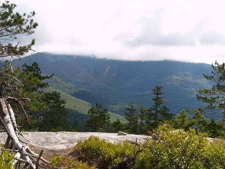
We then reached the first of the ledges and the trail meandered across granite slabs with beautiful red pines and views to the east and south. Mt. Moosilauke, at 4,802 feet, located practically across the street from where we started, hulked by very close. Its two peaks were completely in the clouds, giving us a view of just the lower sections of the mountain.

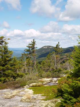
Reindeer lichen, mosses, wintergreen, three-toothed cinquefoil and blueberry (Vaccinium spp.) and huckleberry (Gaylussacia spp.) bushes were abundant on the slabs and the berries provided a welcome treat. Wintergreen (Gaultheria procumbens) is a low-growing plant - usually about 4 inches high - with evergreen leaves that taste and smell like wintergreen. Three-toothed cinquefoil (Potentilla tridentata) is also evergreen and grows on ledgy slopes between rocks. Unlike most species in its genus, the leaves are composed of three leaflets instead of five.
 We wondered about the red pines (Pinus resinosa): whether or not they were native to New Hampshire; whether they were planted or grew naturally. Charles Fergus, in his book
Trees of New England, provides answers to these musings. Red pines are native to New Hampshire and they prefer dry slopes and rocky ridges. And the pines we saw must have been natural because they had the typical understory plants of huckleberry, blueberry, wintergreen, and bracken fern; whereas with red pine plantations there is usually nothing growing in the understory. Fergus goes on to assert that "whenever red pines occur in a pure or a near-pure stand, you can be fairly certain that a fire swept through the area in the past, suddenly baring the land."
We wondered about the red pines (Pinus resinosa): whether or not they were native to New Hampshire; whether they were planted or grew naturally. Charles Fergus, in his book
Trees of New England, provides answers to these musings. Red pines are native to New Hampshire and they prefer dry slopes and rocky ridges. And the pines we saw must have been natural because they had the typical understory plants of huckleberry, blueberry, wintergreen, and bracken fern; whereas with red pine plantations there is usually nothing growing in the understory. Fergus goes on to assert that "whenever red pines occur in a pure or a near-pure stand, you can be fairly certain that a fire swept through the area in the past, suddenly baring the land."We reached the top of the ledges after 1.7 miles of climbing. At this point there is a boulder on the right-hand side of the trail marking the short spur path to the summit of Blueberry Mtn. We followed this easy spur to a rocky outlook of the surrounding mountains that had to be viewed from a standing position because the summit area is quite small and surrounded by conifers. Due to the small area and cooling breeze, we decided to descend just a bit for lunch.
|
|
|||||
|
|
|||||


Next the trail alternated between short spurts through conifers and wonderful open granite slabs with views to the west and north. The first peak you'll probably notice to the north (to the right of the trail as you first start to descend) is Sugarloaf Mtn. (2609'). To the right, and a bit farther out from that are Black Mtn. (2830') and Howe Hill (2681'). All three have partially rocky slopes. Closer in is the forest-cloaked Jeffers Mtn. (2994).
 Farther down along the descent, the views out across the Connecticut River Valley and into Vermont are more distant but still breathtakingly beautiful.
We passed over a thick band of white quartz running across the trail. Red pines grow on these slabs too although not as numerously as on the other side of the mountain. The berry bushes were also present, along with "islands" of lichen and mosses. And there were abundant, dense mats of black crowberry (Empetrum nigrum). Crowberry, although ground-hugging, is actually considered to be a shrub and is part of the heath family. Its leaves are evergreen and tiny (less than 1/4 of an inch long) and crowd around the stems, forming lovely carpets of shining green.
Speaking of carpets, all of these ground-hugging plants, lichens, and mosses are very sensitive and should not be walked upon or sat upon. Stick to the trail or the bare rock whenever possible.
Some of the bushes and plant leaves were starting to turn Autumn-red. We passed by some maroon colored sphagnum moss interspersed with the dense green leaves of wintergreen, providing a pleasing contrast.

After dropping down below the ledges and passing through a section of evergreen trees, the trail then reenters hardwood growth and the slope eases, making for smooth walking instead of the few rock scrambles and moderately pitched slabs up above.
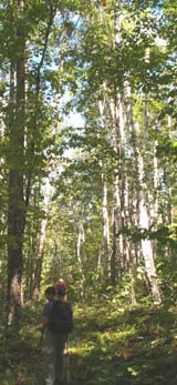
The route crossed several low-water streams, sometimes on rocking or wet, mossy stones so watch your step. After one of the early stream crossings was a short muddy section with moose prints. The breeze provided a pleasant, light, rustling as it made its way through the leaves in the treetops. We passed by a large grove of tall birch trees. The trail was refreshingly soft and grassy in stretches.
White wood aster (Aster divaricatus) was in bloom with its thin, white, sort of scraggly-looking petals (actually bracts). We also passed by some shining clubmoss and some running cedar with its pitchfork-shaped fertile shoots rising above the ground-hugging portion of the plant. Clubmosses despite their name and tiny, evergreen leaves, are more closely related to ferns and horsetails than they are mosses.
 We came upon Indian cucumber root (Medeola virginiana) boasting a very dark berry. Also in fruit was some false Solomon's seal (Smilacina racemosa) which grows upwards a bit then bends almost horizontally with the fruit protruding off the end of the stem in a clump. At this point the fruit was sort of whitish-transparent with red speckles.
Halfway down the mountain, we entered an area that long ago was a farming region. There were stone walls along the trail evidencing this as well as some "pasture-grown" trees: trees that branch out fairly close to the ground and have wide-spreading crowns. When a tree stands alone, as in a field, it has ample sun and can afford to spread itself out; whereas while growing within the woods, trees tend to shoot straight up and have narrow crowns. (To learn more about interpreting the history of the forest, check out the excellent and beautiful book, Reading the Forested Landscape, by Tom Wessels.) We walked past a magnificent old branching maple. Beech, maple, and oak were plentiful in this section and acorns littered the trail. Reportedly, there are old cellar holes in this vicinity.
In one of the grassy-trail sections farther down, an old logging road joins the trail from the right; just continue straight ahead here. Below this was a small woods opening providing a blue-sky background for a tall, majestic-looking white pine.
 Next we encountered a surprise plant: closed gentian (also known as bottle gentian). Closed gentian (Gentiana andrewsii) has a stunning purple flower that looks more like an elongated bud than a flower; it never opens, hence its name of "closed". This plant grows within New England in Massachusetts and Vermont, but not normally in New Hampshire; but then again we weren't really that far from the Vermont line. Gentian likes moist meadows and woodland openings and with the many stream crossings, and a brook running alongside the latter part of the trail, the plant was in an ideal habitat.
And shortly after this we could see a gate ahead, as a logging road joined in from the right, marking the end of the trail. Here we used the car that we spotted earlier to drive back to the eastern trailhead where the rest of our vehicles were parked. We all agreed it was a wonderful hike.
|
|||||

 Driving Directions
Eastern trailhead on Long Pond Road: From Rt. 25 in Glencliff, turn onto High Street and follow for 1.0 mile. Then turn left onto Long Pond Road and follow it for 0.8 mile, then turn left into a small parking area.
The signed trailhead is in the parking lot, opposite from the entrance.
Western trailhead on Blueberry Mountain Road: From Rt. 25 in East Haverhill, turn onto Lime Kiln Road. After 1.4 miles you will come upon a road junction where Lime Kiln Road goes left and Page Road goes straight or to the right; you want to bear right here and follow Page Road for 1.0 mile. Next bear left onto Blueberry Mountain Road and go 0.1 mile. At this point there will be a gate across the road which you should not drive by even if the gate happens to be open; instead, there's a field on the right where parking is allowed.
The trailhead is straight-ahead on the road.

If doing this hike from the opposite direction (starting at Blueberry Mountain Road), remember to bear right at the two trail junctions you'll encounter during the lower part of the trail. The first one is almost immediate and rather obvious because the left-hand turn would be on a cleared dirt road rather than a wide trail-like route. The second junction is also easy to spot but both routes are wide and grassy, but bearing right is the right way.
Long Pond Road is closed during the winter.
Blueberry Mountain Road is not usually plowed.
The eastern trailhead is part of the WMNF so a parking pass is required.
WMNF Recreational Pass
A parking permit is required to park at White Mountain National Forest trailheads and parking areas. You can purchase a WMNF permit from the forest service and other vendors and can also pay-by-the-day using self-service kiosks located in many parking areas.
For more information on parking passes please refer to the White Mountain National Forest website.
Rates:
- $5 per day
- $30 for a year-long pass
- $40 for a year for a household

Website by
![]() LeapfrogProgramming.com
LeapfrogProgramming.com
© 1998-2025
![]()
| The information on this site may freely be used for personal purposes but may not be replicated on other websites or publications. If you want to reference some content on this site, please link to us. |


