
Midstate Trail: Ware River and Savage Hill WMA
| Destinations: | Ware River, Savage Hill Wildlife Management Area | |
| Trail: | Midstate Trail from Barre to Princeton | |
| Region: | MA - Central North | |
| Location: | Barre, MA | |
| Rating: | Easy | |
| Features: | Wetlands, brooks, rivers | |
| Distance: | 8.5 miles | |
| Elevation Gain: | 600 feet (cumulative) | |
| Hiking Time: | Actual: 3:20 Typical: 4:30 | |
| Outing Duration: | Actual: 4:00 Typical: 6:00 | |
| Season: | Spring | |
| Hike Date: | 06/01/2008 (Sunday) | |
| Weather: | About 70 degrees, sunny | |
| Author: | Webmaster | |
| Companion: | A bunch of Midstaters |
Route Summary
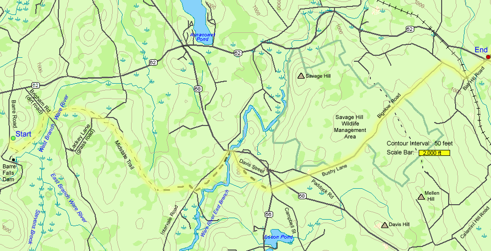
This was a point-to-point hike along the Midstate Trail, starting in Barre and ending in Princeton. The route, which follows a combination of trails and roads, is well blazed with yellow triangles. The roads you'll be walking on are very lightly traveled but the roads you cross can be busy with fast traffic so please use caution. Pay attention to the blazes to ensure you don't veer off on any intersecting trails. Some waypoints are described below to help keep you on track.
- From the upper parking area at Barre Falls Dam, head downhill on the road for about 50 yards, then turn left onto a dirt road. Since the Midstate Trail doesn't actually start from the parking lot, you won't start seeing the blazes until about the time the dirt road turns towards the left, only about a quarter-mile from the parking area. (Ignore a right-hand turn onto a narrow trail shortly before this which is the Midstate Trail going in the opposite direction.)
- Follow this road which starts out amongst fields and groves of trees and then enters the woods with the West Branch of the Ware River to the right.
- Turn right to cross the Ware River on a bridge 0.9 mile from the parking area. Immediately after the bridge, the trail turns left and heads up a wide grassy track.
- After 0.7 mile you will reach an intersection with a grass road; go straight across.
- The paved Intervale Road, 2.0 miles later will be your next landmark. Cross the road to pick up the Midstate Trail on the other side.
- After 0.7 mile you will come out to Route 68. In this segment between Intervale Road and Route 68, the East Branch of the Ware River will appear to your right.
- Cross the highway bridge over the river, then immediately turn right and head uphill on Davis Street.
- After 0.6 mile, turn right onto a woods road.
- Just 0.2 mile later cross Route 56 (caution: fast traffic) onto Bushy Lane.
- After another 0.2 mile cross Route 68 (caution: fast traffic) to continue your walk on Bushy Lane.
- After 0.3 mile cross Paddock Road and continue on Bushy Lane.
- Continue on this road which will eventually become Bigelow Road. You will reach a T-intersection with West Cemetery in front of you 2.2 miles from the Paddock Road crossing.
- Turn right to follow the road downhill land arrive at a T-intersection with Ball Hill Road 0.3 mile later.
- Turn left onto Ball Hill Road and walk to its end where it meets with Route 62 after 0.4 mile.
- Cross Route 62 (caution: fast traffic) to reach your vehicle that should have been spotted here before starting the hike.
| Place | Split Miles |
Total Miles |
Split Time |
Total Time |
|||||
|---|---|---|---|---|---|---|---|---|---|
| Upper lot at Barre Falls Dam (860') | 0.0 | 0.0 | 0:00 | 0:00 | |||||
| Intersection with grass road | 1.6 | 1.6 | 0:42 | 0:42 | |||||
| Intervale Road crossing | 2.0 | 3.6 | 0:51 | 1:33 | |||||
| Route 68 bridge (876') | 0.7 | 4.3 | 0:20 | 1:53 | |||||
| Jct. Davis Street/woods road | 0.6 | 4.9 | 0:12 | 2:05 | |||||
| Route 56 crossing (1050') | 0.2 | 5.1 | 0:05 | 2:10 | |||||
| Route 68 crossing (1060') | 0.2 | 5.3 | 0:03 | 2:13 | |||||
| Paddock Road crossing | 0.3 | 5.6 | 0:07 | 2:20 | |||||
| West Cemetery (980') | 2.2 | 7.8 | 0:48 | 3:08 | |||||
| Jct. Ball Hill Road | 0.4 | 8.2 | 0:07 | 3:15 | |||||
| Route 62 (961') | 0.3 | 8.5 | 0:07 | 3:22 |

|
|
|||||


|
|
|||||


This was an easy and pleasant walk on the Midstate Trail covering both wooded paths and little-traveled roads. A large group of hikers started out together and soon spread out, according to paces, in smaller groups. I, as usual, was in the rear position, taking lots of photos and enjoying all the interesting sights.
We started this segment of the Midstate Trail from the upper parking lot at Barre Falls Dam so the beginning was on wide paths through the dam's recreation area with views of the dam, the West Branch of Ware River, and lush green lawns. We soon entered shady woods with the small, dark river running to the right.

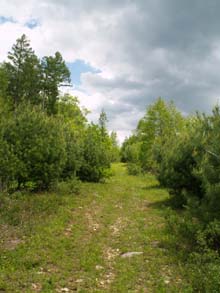
After crossing a bridge we veered left away from the river, uphill on a wide, open, grassy track with lots of interesting shrubs and flowers. We saw the remains of some small trees/shrubs that had been chopped down and taken away by beavers. There were some pink lady's slippers (Cypripedium acaule) sheltering in the shade provided by bushes. Close to the ground, Canada Mayflower (Maianthemum canadense) was sporting its cluster of tiny white flowers. Another low-growing plant, fringed polygala (Polygala paucifolia), had delightful hot-pink flowers.
Common cinquefoil (Pontentilla simplex) was displaying its bright-yellow flowers. Like most cinquefoils, this one has palmate leaves with five leaflets; if you were to spread your fingers apart and look at your hand, that's sort of what cinquefoil leaves look like, except they're not that big (and they are green which hopefully your hand is not). Blue-eyed grass was also in bloom. As its name implies, this plant looks like a tall blade of grass and has a violet colored flower with a yellow center perched near the top.
One of the shrubs encountered was Morrow's honeysuckle (Lonicera morrowi) which had interesting blossoms that ranged from white to a creamy pale yellow to a brighter yellow. Blueberry was another bush in flower along this trail, sporting delicate-looking, white, bell-shaped blooms. Blackberry with its large thorns was pretty to look at with its bright white, five-petaled flowers.

Sweet fern (Comptonia peregrina) was noticeable for its appealing scent. This shrub grows to about two feet high and has long narrow leaves with the edges cut in such a way as to make one think of ferns. It has no discernible flowers; it's the leaves that are aromatic. Rising above the bushy undergrowth were some tall, beautiful tamarack trees as well as some young pine trees.
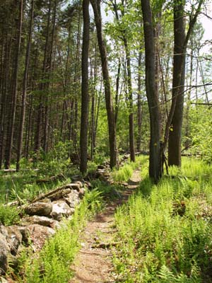
Later, the path narrowed and entered into wooded areas with stone walls and several species of ferns. One of which was cinnamon fern (Osmunda cinnamomea) which grows in a clump reaching over two feet tall. It often has a fertile, cinnamon-colored frond or spike growing at its center. It's this frond that contains the spores that will cause the fern to spread, although the plant can also spread vegetatively via its rhizomes.


The evergreen wintergreen plant (Gaultheria procumbens) was growing low to the ground. If you break a leaf in half you will be able to detect its wintergreen scent; this is what's used to flavor tea, candies, medicines, and chewing gum. Goldthread (Coptis groenlandica) and partridgeberry (Mitchella repens) were other evergreen plants hugging the ground. Some of the partridgeberry plants were bearing bright red berries. Creeping cedar, a clubmoss, and yet another evergreen was doing its part to liven up the brown leaf-litter of the forest floor.
At one point we came to big rounded hump about five feet tall near the trail that was covered by a bunch of medium-sized rocks. I have no idea was it was but it certainly looked out of place. Shortly after that we came upon some gorgeous, large early azalea shrubs (Rhododendron roseum). The blooms were pink and were almost two inches wide. The base of the flowers were fused together and red in color as were the long, curved, protruding stamens. The leaves had a rather unique look to them too; they were arranged in whorls of five on the very tips of the branchlets.

Farther along the trail we happened upon a tree scratched at about six feet above the ground - where a moose probably rubbed its antlers. We didn't actually see the moose but we did see a red newt which was almost as exciting. This small dark orange salamander has bright orange iridescent spots. He entertained us as he climbed across some leaf litter and up a mossy rock. It was fun watching his little legs and toes move and grab in order to gain purchase and pull himself up the steep wall of the little boulder, looking much like a rock climber... or maybe it's the rock climbers that look like salamanders.
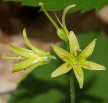
We passed through a wet area, went by a neat large boulder, then reached drier ground where we saw starflower (Trientalis borealis), a white bloom with 5-9 petals, yellow clintonia (Clintonia borealis), a pretty, bell-shaped, light yellow flower, and more pink lady's slippers. We also encountered a chipmunk making a racket and looking at us from atop a stone wall.

After crossing Intervale Road, we came upon some wetlands. Growing in a stream that we crossed was marsh blue violet (Viola cucullata). Later we saw painted trillium (Trillium undulatum), which has three leaves, three sepals, and three white petals that are "painted" with dark pink near the center. There were some rattlesnake plantain plants which have very distinctive leaves covered in a white veiny pattern resembling snake skin.
We soon met up with the Ware River again, this time the East Branch instead of the West. The water still looked dark and had a rocky, shady shoreline. At one point there was an old bridge abutment which would be a good spot for a lunch break since it's about halfway through the hike and has room for a small group to sit and enjoy the scenery. Upstream there were some large boulders in the middle of the waterway.
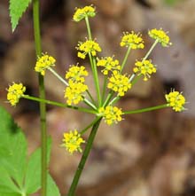
In this section we also saw some false Solomon's Seal (Smilacina racemosa) and golden Alexanders in bloom. After a rather short stint along the river, we climbed up a short hill and emerged out at a small parking area on Route 68 where there were some flowering chokecherry trees (Prunus virginia).

From this point on, today's hike route was mostly on roads - although many parts are so lightly traveled as to feel like trails and one of the roads is mostly gravel/dirt/grass. From the bridge on Route 68 is a nice upstream view of the Ware River where it runs much wider. We crossed the bridge then immediately turned off of the busy Route 68 onto the quiet residential Davis Street. After an uphill climb, we soon dipped back onto a woods trail. We emerged from the woods to cross Route 56 and started our walk on Bushy Lane which at this point is another residential street although it later turns into all woods.
After a couple more street crossings, but still on Bushy Lane, we entered the Savage Hill Wildlife Management Area. This preserve consists of 452 acres and encompasses Savage Hill as well as a wide expanse of open marsh. At one point, the noise the abundant frogs were producing was incredibly loud. The wetlands were filled with a "forest" of tall, bare snags, and lush green ferns and grass that made it strangely beautiful in spite of the dead trees. The soft, wide track led gently uphill away from the wetlands and through woods.

Shortly after the height-of-land, we exited the preserve. The road at this point is Bigelow Road and it heads downhill and houses once again dot the scenery, although woods are still pretty dominant. We saw a woody vine twining its way up a tall tree. The main part of the thick vine was securely anchored to the tree but smaller twigs branched off the main "trunk", stretching its "arms" wide and bearing leaves much like a tree itself.
At the bottom of Bigelow Road, at a T-junction was a cemetery. We turned right and headed downhill some more, and under a railroad bridge, before reaching Ball Hill Road where we turned left. A short walk on this road, past a pretty stream, brought us to Route 62 where we had earlier left our cars, marking the end of our Midstate Trail trek for the day.

|
|
|||||

|
|||||


|
|
|||||



Barre Falls Dam Upper Parking Lot:
- Barre Falls Dam, the start point for this hike, is located in Barre, Massachusetts and is accessible from Route 62.
- When heading west on Route 62, travel 2.2 miles from the intersection of Routes 62 and 68, then turn left onto the dam access road. Heading east, travel about 4.3 miles from Barre's town square, then turn right onto the dam access road. There is a sign for the dam at the turn.
- Follow the road for about 0.6 mile, then pull into the first parking lot on the left (the dam itself is just a bit
 farther down this road).
Jct. Route 62 and Ball Hill Road:
- The end point for this hike is located in Princeton, Massachusetts at the junction of Route 62 and Ball Hill Road.
- When heading west on Route 62, Ball Hill Road will be on the left 2.3 miles after the junction with Routes 62 and 31. When heading east on Route 62, Ball Hill Road will be on the right 2.0 miles from the junction of Routes 62 and 68.
- Park on Route 62, off the pavement, across the street from Ball Hill Road, being careful not to block access to a nearby driveway.
Jct. Route 68 and Ware River East Branch:
- Although you don't need to drive to this parking area for this hike, access information is provided in case you want to hike a shorter section of the trail. This parking area is located in Rutland, Massachusetts.
- When traveling southeast on Route 68, the bridge over the East Branch of Ware River will be about 1.4 miles from the junction of Routes 62 and 68. The river won't be noticeable from the road on the right-hand side but covers a fairly wide area on the left-hand side of the road.
- There is a dirt parking area on the right side of the road just before the bridge.
- The Midstate Trail leads into the woods from this parking area in one direction; and in the other direction you would cross the bridge and then turn right up Davis Street to follow the "trail" (which is a road at this point in that direction).

Facilities
Another parking area and a picnic area with restrooms is located at Barre Falls Dam, about a half mile below the upper parking area and just after the dam itself.


 The Midstate Trail is a 92-mile hiking trail traversing Massachusetts from Rhode Island to New Hampshire. It runs through Worcester County, 45 miles west of Boston. Although it is close to populated areas, it manages to wind through scenic and wild segments of the state, climbing gentle hills and mountains and encountering lakes, ponds, streams, meadows, and woods.
To the south, the trail connects with Rhode Island's North-South Trail which extends the hiking possibilities 75 miles all the way to the Atlantic Ocean. And to the north, it connects to the Wapack Trail in New Hampshire which covers an additional 21 miles and ends at North Pack Monadnock in Greenfield.
The Midstate Trail crosses the 2,006-foot peak of Wachusett Mountain which is the highest point on the route. On a clear day the Boston skyline is visible to the east, Mount Monadnock to the north, and the Berkshire Hills to the west.
Another notable peak is Mount Watatic which reaches 1,832 feet. This is the last undeveloped mountain in the state east of the Connecticut River. The peak provides views in all directions including Boston, central and western Massachusetts, the Green Mountains of Vermont, and the mountains of southern New Hampshire. Both Watatic and Wachusett are great spots to watch hawk migrations.
Mount Hunger offers gorgeous 360-degree views of surrounding lakes, ponds, hills and ridges. And the Crow Hill ledges in Leominster State Park provide great outlooks to Crow Hill Pond and Crocker Pond just below. The ledges themselves are a popular climbing spot.
Other interesting features along the route include Hodges Village Dam, Moose Hill, Sampson's Pebble (an enormous glacial erratic), Barre Falls Dam, historic Redemption Rock, and Muddy Pond (an attractive, remote, and undeveloped glacial pond). Abundant stone walls scattered through the woods are a reminder that the land was used as farmland back in the 1800's.
Along the way you will explore many forests and reserves including Douglas State Forest, Four Chimneys Wildlife Management Area, Spencer State Forest, Moose Hill Wildlife Management Area, Buck Hill Reserve, Oakham State Forest, Rutland State Park, Savage Hill Wildlife Management Area, Wachusett Meadow Wildlife Sanctuary, Wachusett Mountain State Reservation, and Leominster State Forest.
The Midstate Trail is highly accessible and for the most part the hiking is easy with occasional steep and rugged sections. It is well blazed with yellow triangles. The route, as with any long-distance trail, follows roads for some (usually short) segments. The trail is also used for snowshoeing, mountain biking, and cross-country skiing. Several primitive lean-to's and campsites are available along the route; however, camping is prohibited in most areas.
The trail is maintained and managed by the Midstate Trail Committee under the guidance of the Worcester chapter of the Appalachian Mountain Club. An annual end-to-end hike takes place over the summer with a patch awarded to those who complete the entire length. See the Midstate Trail's website for the hiking schedule or to purchase the latest version of the Midstate Trail Guidebook.
The southern terminus of the Midstate Trail is located on the Rhode Island border in Douglas, Massachusetts in Douglas State Forest. The northern end is on the New Hampshire border on the Ashburnham/Ashby, Massachusetts town line just north of the summit of Mount Watatic.


Website by
![]() LeapfrogProgramming.com
LeapfrogProgramming.com
© 1998-2025
![]()
| The information on this site may freely be used for personal purposes but may not be replicated on other websites or publications. If you want to reference some content on this site, please link to us. |


